Google Maps Traffic API
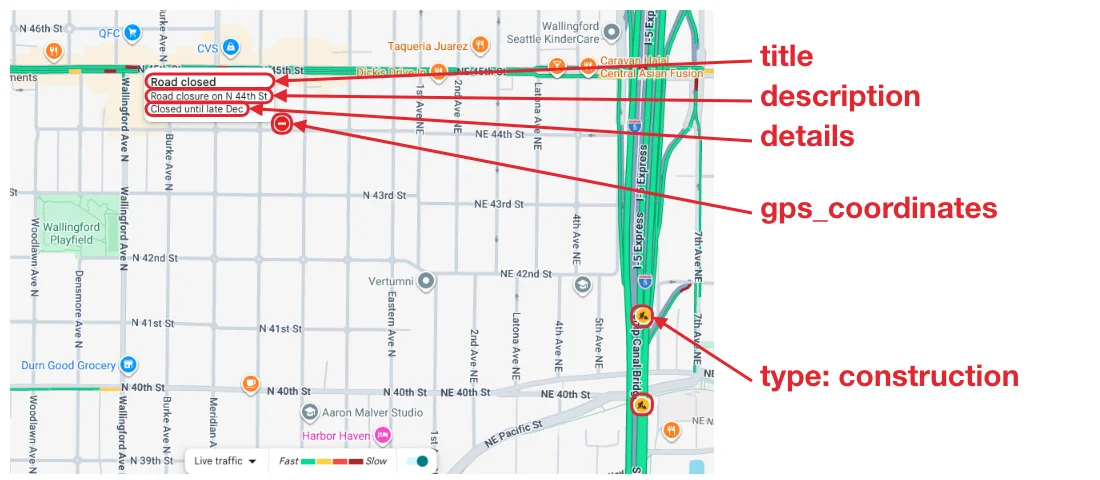
Our Google Maps Traffic API allows you to scrape the live traffic incidents of Google Maps in any area: road closures, construction zones, and crashes. For each incident, the API returns its type, title, description and details (e.g., "Closed until late Dec"), GPS coordinates, and the time it was last updated.
Define the area with bbox, the zoom level of the map with zoom, and the language of the incidents with hl.
The API endpoint is https://serpapi.com/search?engine=google_maps_traffic
Head to the playground for a live and interactive demo.
API parameters
Search query
bbox
Required
Parameter defines the area to get traffic incidents for. The value consists of latitude/longitude pairs: the first pair marks the top left corner and the second pair marks the bottom right corner of the map area box.
It has to be constructed in the next sequence:latitude_tl + , + longitude_tl + , + latitude_br + , + longitude_br
This will form a string that looks like this: e.g. 47.68,-122.42,47.58,-122.27 (Seattle, WA).
Localization
gl
Optional
Parameter defines the country to use for the Google Maps search. It's a two-letter country code. (e.g., us (default) for the United States, uk for United Kingdom, or fr for France) Head to the Google countries page for a full list of supported Google countries.
hl
Optional
Parameter defines the language of the traffic incidents. It's a two-letter language code. (e.g., en (default) for English, de for German, or ja for Japanese). Head to the Google languages page for a full list of supported Google languages.
Advanced parameters
zoom
Optional
Parameter defines the zoom level of the map to get traffic incidents at, from 10 to 21. It defaults to 16.
Like on Google Maps, more incidents are shown at higher zoom levels: a long road closure or construction zone is marked several times along the road, and nearby incidents are only shown when zoomed in.
Large areas need a lower zoom: an area can span up to 1024 map tiles of 256 pixels at the chosen zoom.
 SerpApi parameters
no_cache
Optional
Parameter will force SerpApi to fetch the Google Maps Traffic results even if a cached version is already present. A cache is served only if the query and all parameters are exactly the same. Cache expires after 1h. Cached searches are free, and are not counted towards your searches per month. It can be set to false (default) to allow results from the cache, or true to disallow results from the cache. no_cache and async parameters should not be used together.
async
Optional
Parameter defines the way you want to submit your search to SerpApi. It can be set to false (default) to open an HTTP connection and keep it open until you got your search results, or true to just submit your search to SerpApi and retrieve them later. In this case, you'll need to use our Searches Archive API to retrieve your results. async and no_cache parameters should not be used together. async should not be used on accounts with Ludicrous Speed enabled.
zero_trace
Optional
Enterprise only. Parameter enables ZeroTrace mode. It can be set to false (default) or true. Enable this mode to skip storing search parameters, search files, and search metadata on our servers. This may make debugging more difficult.
output
Optional
Parameter defines the format of the result. It can be set to json (default) to get a structured JSON of the results, html to get the raw HTML retrieved, or md to get a Markdown-formatted version optimized for LLMs and AI agents.
json_restrictor
Optional
Parameter defines the fields you want to include in the output, reducing payload size for faster response. See the JSON Restrictor documentation for more details.
API results
JSON results
JSON output includes structured data for traffic incidents.
A search status is accessible through search_metadata.status.
It flows this way: Processing -> Success || Error.
If a search has failed, error will contain an error message.
search_metadata.id is the search ID inside SerpApi.
HTML results
This API does not have a full HTML response, only text.
search_metadata.prettify_html_file contains a link to the prettified version of the result.
It is displayed in the playground.
Markdown results
Markdown output is optimized for LLMs and AI agents. It provides a curated view of the JSON results
in a token-efficient format using tables, markdown links, and YAML frontmatter.
To access, use the output=md parameter, the /search.md endpoint, or request header Accept: text/markdown.
API examples
Result for bbox: 47.6668,-122.3459,47.6538,-122.3165
Incidents are the ones Google Maps shows on its live traffic layer, with the text of the card Google Maps shows when you point at them: title, description, and details. Like on Google Maps, a long construction zone or road closure is marked several times along the road, each with its own incident_id.
{
  ...
  "traffic_incidents": [
    {
      "position": 1,
      "incident_id": "2325972149991207895",
      "type": "construction",
      "title": "Construction zone",
      "details": [
        "Construction ends Jan 2027"
      ],
      "gps_coordinates": {
        "latitude": 47.6541,
        "longitude": -122.3223782
      },
      "last_updated": "2026-10-20T07:33:03Z"
    },
    ...
    {
      "position": 4,
      "incident_id": "2377773130162442402",
      "type": "road_closed",
      "title": "Road closed",
      "description": "Road closure on N 44th St",
      "details": [
        "Closed until late Dec"
      ],
      "gps_coordinates": {
        "latitude": 47.6603004,
        "longitude": -122.3319912
      },
      "last_updated": "2026-07-30T20:44:53Z"
    }
  ]
}
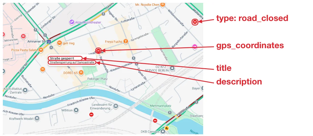
Result for bbox: 52.5474,13.3403,52.5357,13.3697 and hl: de
Titles and descriptions are in the language of hl, like on Google Maps. Google Maps only has details in English.
{
  ...
  "traffic_incidents": [
    {
      "position": 1,
      "incident_id": "14294393341000860422",
      "type": "road_closed",
      "title": "Straße gesperrt",
      "description": "Straßensperrung auf Burgsdorfstraße",
      "gps_coordinates": {
        "latitude": 52.5432422,
        "longitude": 13.3633018
      },
      "last_updated": "2026-10-01T15:27:43Z"
    },
    {
      "position": 2,
      "incident_id": "9758934030219847095",
      "type": "road_closed",
      "title": "Straße gesperrt",
      "description": "Straßensperrung auf Samoastraße",
      "gps_coordinates": {
        "latitude": 52.5415587,
        "longitude": 13.3542037
      },
      "last_updated": "2026-10-18T04:12:53Z"
    },
    ...
    {
      "position": 5,
      "incident_id": "7970665993332877028",
      "type": "construction",
      "title": "Baustelle",
      "description": "Baustelle auf Perleberger Str.",
      "gps_coordinates": {
        "latitude": 52.5373041,
        "longitude": 13.3603621
      },
      "last_updated": "2026-10-20T07:33:03Z"
    },
    ...
  ]
}
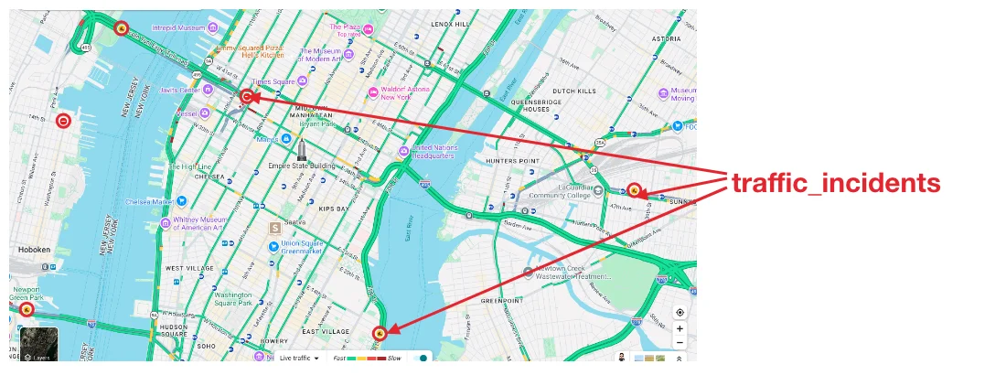
Result for bbox: 40.7793,-74.0356,40.7207,-73.9182 and zoom: 14
Use a lower zoom for larger areas. Like on Google Maps, fewer incidents are shown when zoomed out: nearby incidents and repeated markers along a road are only shown at higher zoom levels.
{
  ...
  "traffic_incidents": [
    {
      "position": 1,
      "incident_id": "11480402140484633262",
      "type": "construction",
      "title": "Construction zone",
      "details": [
        "Construction ends 3:30 PM"
      ],
      "gps_coordinates": {
        "latitude": 40.7443958,
        "longitude": -73.9289761
      },
      "last_updated": "2026-10-20T07:32:27Z"
    },
    {
      "position": 2,
      "incident_id": "1409411668714192897",
      "type": "construction",
      "title": "Construction zone",
      "description": "Road work on FDR Dr",
      "gps_coordinates": {
        "latitude": 40.7250147,
        "longitude": -73.9727497
      },
      "last_updated": "2026-10-20T07:32:32Z"
    },
    {
      "position": 3,
      "incident_id": "11253091091454427827",
      "type": "road_closed",
      "title": "Road closed",
      "gps_coordinates": {
        "latitude": 40.7555796,
        "longitude": -73.995924
      },
      "last_updated": "2026-08-15T21:36:48Z"
    },
    ...
  ]
}
JSON structure overview
{
  "search_metadata": {
    "id": "String - Search ID",
    "status": "String - Search status (Ex. Success, Processing, Error)",
    "json_endpoint": "String - URL to the JSON results",
    "created_at": "String - Timestamp of the search creation",
    "processed_at": "String - Timestamp of the search processing",
    "google_maps_traffic_url": "String - URL of the area on Google Maps, with the live traffic layer",
    "raw_html_file": "String - URL to the raw responses of Google Maps",
    "prettify_html_file": "String - URL to the prettified HTML of the results",
    "total_time_taken": "Float - Time taken to process the search"
  },
  "search_parameters": {
    "engine": "String - Engine used (google_maps_traffic)",
    "bbox": "String - Map area box",
    "zoom": "String - Zoom level of the map",
    "hl": "String - Language",
    "gl": "String - Country"
  },
  "traffic_incidents": [
    {
      "position": "Integer - Position of the incident",
      "incident_id": "String - ID of the incident marker on Google Maps. Google Maps can return a different ID for the same incident in another search",
      "type": "String - Type of the incident: road_closed, construction, or crash. Missing for other kinds of incidents",
      "title": "String - Title of the incident, in the language of hl (Ex. Road closed)",
      "description": "String - Description of the incident (Ex. Road closure on N 44th St). Missing when Google Maps doesn't show one",
      "details": "Array[String] - Details of the incident (Ex. [\"Closed until late Dec\"]). Missing when Google Maps doesn't show any",
      "gps_coordinates": {
        "latitude": "Float - Latitude of the incident marker",
        "longitude": "Float - Longitude of the incident marker"
      },
      "last_updated": "String - Time the incident was last updated, in ISO 8601 (UTC)"
    }
  ],
  "error": "String - Error message, when there are no traffic incidents in the area"
}